Increasing global temperatures, and an accumulation of excess agricultural nutrients and fertilizers over recent decades has created favourable conditions for algae blooms in both marine and freshwater environments.
With thousands of algae species, only some are classified as harmful due to their toxic effects on humans and wildlife. Small concentrations of algae are present throughout oceans and watersheds, and some toxic species may only be present in small quantities to be a danger to humans, such as Alexandrium fundyense, the algae responsible for paralytic shellfish poisoning, and microcystin-producing cyanobacteria, which is toxic to wildlife and humans.
Harmful algal blooms (HABs) are an overwhelming concentration of algae, clearly visible to the naked eye. Toxic and non-toxic blooms can be harmful, as their sudden growth can cause waters below the bloom to become anoxic. Resulting conditions from anoxic bloom environments have led to large-scale deaths of aquatic animals.
Despite the widespread occurrence of algae blooms, they are difficult and costly to observe. Blooms can suddenly appear in waterways that have never experienced HABs before, and are more likely to reoccur after their first instance. Due to the toxic nature of certain algaes, it is an increasingly high priority for members of industry, government, and non-profit organizations to monitor waterways and coastlines for the presence of blooms. Staffing and fieldwork costs are a limiting factor in monitoring areas of interest. Furthermore, current testing methods to see if algal samples contain toxins take weeks to provide results, often outlasting the lifespan of the HAB itself.
Innovative technologies such as remote water monitoring buoys have been released commercially in recent years, but they are limited by their ability to only alert to algal presence in waters that come in contact with the monitoring station.
Darlings Lake, New Brunswick is a local example of sudden, increased algae blooms in Canada. In July 2021, the bloom experienced its first large-scale HAB event. Cyanobacteria encapsulated the lake for almost two weeks and continued to reappear throughout the summer and early fall. Since then, Darlings Lake has experienced large cyanobacteria blooms each summer.
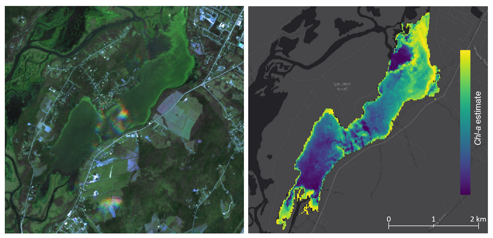
In 2022 MERIDIAN began a pilot project testing the accuracy of high-resolution satellite imagery to map HAB extent and severity. In partnership with the Hammond River Angling Association and ACAP Saint John, our team has studied HAB activity using satellite imagery from Planet Labs taken in 2021 and 2022. Our forthcoming research paper, “Monitoring Harmful Algae Blooms in Darlings Lake, New Brunswick, using K-means Clustering of Multispectral Satellite Imagery”, outlines a methodology to highlight bloom activity, while reducing false positive signals from existing vegetation. Bloom extent, severity, and frequency were able to be highlighted on cloud-free days over Darlings Lake. Even more promising, derived NDCI signals were able to be correlated to in-water measurements of cyanobacteria concentrations with a high degree of success.
Currently MERIDIAN is expanding tests of algae detection efforts in marine environments. This is thanks in part to generous funding from the Ocean Frontier Institute, who are supporting our efforts to develop the SMART-HAB application – a tool in development to automatically download, process, and output results of HAB activity.
Resources and links for further reading:
[4] Challenges in tracking harmful algal blooms: A synthesis of evidence from Lake Erie
[5] Unbelievably visible’ blue-green algae cropping up in more N.B. waterways